Catálogo Oficial de Datos y Servicios INSPIRE (CODSI)
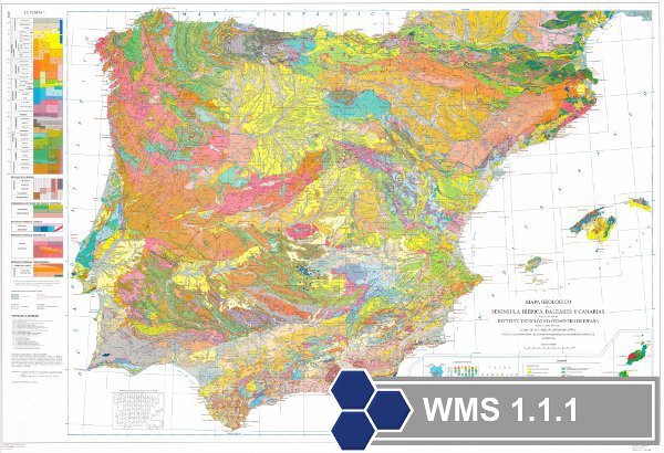
WMS del Mapa Geológico de la Península Ibérica, Baleares y Canarias a escala 1M del Instituto Geológico y Minero de España
Mapa Geológico de la Península Ibérica, Baleares y Canarias a escala 1M. Incluye las unidades cronolitoestratigráficas y la representación de la estructura tectónica mediante fallas y cabalgamientos.
Simple
Identification info
- Date (Creation)
- 2009-03-01
- Point of contact
-
Organisation name Individual name Electronic mail address Role Instituto Geológico y Minero de España (IGME)
Point of contact
- Keywords
-
-
IGME
-
IDEE
-
Mapa Geologico
-
-
ISO - 19119 geographic services taxonomy
-
-
infoMapAccessService
-
Servicio de acceso a mapas
-
- Access constraints
- Other restrictions
- Other constraints
- Sin limitaciones al acceso público.
- Use constraints
- Other restrictions
- Other constraints
- No conditions apply
- Other constraints
-
No está permitido implementar un servicio de valor añadido no gratuito sin establecer contacto con el IGME
- Service Type
- view
N
S
E
W
))
- Coupling Type
- Ajustado
- Contains Operations
-
Operation Name Distributed Computing Platforms Connect Point GetCapabilities
Web services https://mapas.igme.es/gis/services/Cartografia_Geologica/IGME_Geologico_1M/MapServer/WMSServer?REQUEST=GetCapabilities&SERVICE=WMS&VERSION=1.3.0 GetMap
Web services https://mapas.igme.es/gis/services/Cartografia_Geologica/IGME_Geologico_1M/MapServer/WMSServer GetfeatureInfo
Web services https://mapas.igme.es/gis/services/Cartografia_Geologica/IGME_Geologico_1M/MapServer/WMSServer
- Distribution format
-
- OnLine resource
-
Protocol Linkage Name OGC Web Map Service https://mapas.igme.es/gis/services/Cartografia_Geologica/IGME_Geologico_1M/MapServer/WMSServer?Request=GetCapabilities&Service=WMS&Version=1.3.0 Servicio de visualización WMS del Mapa Geológico de España a escala 1M
- Hierarchy level
- Service
- Other
-
Servicio de visualización
Conformance result
Conformance result
- Date (Publication)
- 2010-12-08
Citation identifier
No information provided.
- Explanation
- El conjunto de datos no es conforme
- Pass
- No
Conformance result
- Date (Publication)
- 2008-12-04
Citation identifier
No information provided.
- Explanation
- Conforme
- Pass
- Yes
Metadata
- File identifier
- ESPIGMESERVICIOGEOLOGICO1000EDICION19952011021426047 XML
- Metadata language
- Spanish; Castilian
- Hierarchy level
- Service
- Hierarchy level name
-
Servicio
- Date stamp
- 2025-04-03T11:51:45.473133Z
- Metadata standard name
-
Reglamento (CE) Nº 1205/2008 de INSPIRE
- Metadata standard version
-
TG 2.0
- Metadata author
-
Organisation name Individual name Electronic mail address Role Instituto Geológico y Minero de España (IGME)
Gómez Sánchez, Margarita
Point of contact