Catálogo Oficial de Datos y Servicios INSPIRE (CODSI)
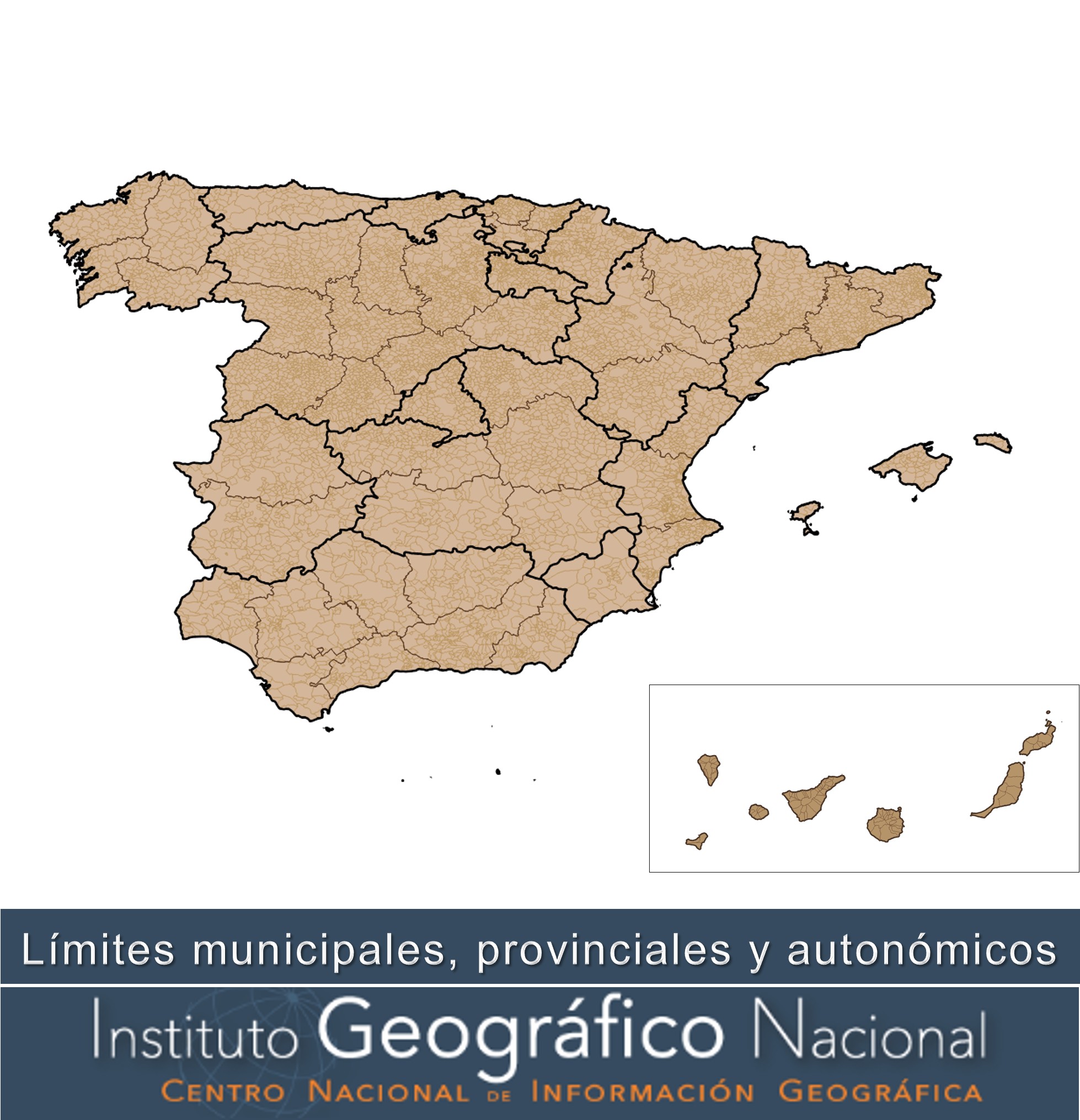
Divisiones Administrativas de España
Administrative Units of Spain
Recintos municipales, provinciales y autonómicos y líneas límite municipales, provinciales y autonómicas inscritos en el Registro Central de Cartografía (RCC)( https://www.ign.es/web/ign/portal/rcc-area-rcc ). La geometría inscrita en el RCC responde a la interpretación de los títulos jurídicos inscritos en el RCC: actas de línea límite, resoluciones administrativas, sentencias judiciales, etc. Algunas líneas o tramos de líneas pueden ser "provisionales", es decir, que carecen de título jurídico que avale su geometría y por tanto su representación en la cartografía solo obedece a la necesidad topológica del cierre de polígonos municipales.
El Real Decreto 1545/2007, de 23 de noviembre, por el que se regula el Sistema Cartográfico Nacional establece entre las funciones del RCC las de inscribir la cartografía oficial, las delimitaciones territoriales y sus variaciones, y recopilar, normalizar y difundir la toponimia oficial. El artículo 20 de este Real Decreto señala que las líneas límite municipales, los límites de las provincias y las delimitaciones de los territorios de las comunidades autónomas son parte de las Delimitaciones Territoriales y por tanto, deben inscribirse en el Registro Central de Cartografía. Asimismo, el artículo 4.1 del mencionado Real Decreto establece que «toda la producción de información geográfica y cartografía oficiales se realizará a partir del Equipamiento Geográfico de Referencia Nacional, que estará integrado por (…); por las Delimitaciones Territoriales inscritas en el Registro Central de Cartografía (...)», es decir, las delimitaciones territoriales usadas en la cartografía oficial deberán ser las inscritas en el RCC.
Hay que señalar que, con carácter general, la geometría con la que figura inscrita cada línea en el RCC tiene una incertidumbre geométrica en torno a 40 metros, según la experiencia y contrastación con trabajos puntuales precisos realizados por el Instituto Geográfico en numerosas líneas límite. Esto es consecuencia de las imprecisiones propias de los métodos e instrumentos topográficos utilizados en su día por el Instituto Geográfico para su levantamiento y posterior trazado sobre el Mapa Topográfico Nacional, a las que hay que añadir las de los procesos de digitalización de dichas líneas límite sobre cartografía impresa, llevados a cabo años después para obtener su versión digital. La excepción a lo anterior son aquellas líneas en las que se han desarrollado una serie de trabajos técnicos y administrativos exigidos por la normativa estatal o autonómica vigente para el deslinde de los términos municipales, lo que ha permitido la inscripción de una geometría más precisa.
Municipal, provincial and autonomous areas and municipal, provincial and Autonomous Community boundaries registered in the Central Register of Cartography ( https://www.ign.es/web/en/ign/portal/rcc-area-rcc ). The geometry reflects the interpretation of the legal titles included in the Central Register of Cartography: limit line minutes, administrative rulings, court rulings etc. may be ‘provisional’, i.e. they do not have a legal title to support their geometry and therefore their representation in the cartography is only due to the topological necessity of the closure of municipal polygons. Royal Decree 1545/2007, of 23 November, governing the National Mapping System, establishes the functions of Central Register of Cartography to record the official cartography, the territorial delineations and their variations, and to collect, standardise and disseminate the official mapping. Article 20 of this Royal Decree states that the municipal boundaries, the boundaries of the provinces and the boundaries of the territories of the Autonomous Communities are part of the territorial restrictions and must therefore be entered in the Central Mapping Register. In addition, Article 4 (1) of the aforementioned Royal Decree provides that ‘all production of official geographical information and mapping shall be carried out using the National Geographic Reference Chart, which shall be composed of (...); by the territorial limitations registered in the Central Mapping Register (...)’, that is to say, the territorial delineations used in the official cartography must be those listed in the Central Register of Cartography. It should be noted that, as a general rule, the geometry with which each line is listed in the Central Register of Cartography has a geometrical uncertainty of around 40 metres, based on the experience and contrast with specific one-off work carried out by the Geographic Institute on a large number of borderline lines. This is the result of inaccuracies in the topographical methods and instruments used at the time by the Geographic Institute for lifting and subsequent mapping on the national topographic map, which should be added to the processes of digitisation of those lines on printed cartography, carried out after years to obtain their digital version. The exception to this is those where a series of technical and administrative work has been carried out as required by the national or Autonomous Community legislation in force for the demarcation of municipal terms in force, allowing for the registration of a more precise geometry.
Simple
-
Date (Creation)Fecha (Creación)
- 2012-01-01
-
Date (Publication)Fecha (Publicación)
- 2020-01-01
-
Date (Revision)Fecha (Revisión)
- 2026-02-12
-
Citation identifierIdentificador del Contacto
- IGN / BDLJE
-
Citation identifierIdentificador del Contacto
- IGN / bdlje_limites_adm
-
Citation identifierIdentificador del Contacto
- IGN / bdlje_unidades_adm
-
Citation identifierIdentificador del Contacto
- IGN / bdlje_limites_hist
- Point of contact
-
Organisation name Individual name Electronic mail address Role Instituto Geográfico Nacional
Spanish National Geographic Institute
OwnerPropietarioCentro Nacional de Información Geográfica (CNIG)
National Centre of Geographic Information (CNIG)
PublisherPublicador
-
Maintenance and update frequencyMantenimiento y frecuencia de actualización
-
QuarterlyTrimestralmente
-
Update scopeAlcance de las actualizaciones
-
DatasetConjunto de datos
-
Nota de mantenimient
-
Actualización trimestral
- Keywords
- Keywords
-
-
IGN
-
Líneas Límite
-
-
Uso específicoSpecific usage
-
Información geográfica de referencia de los recintos municipales, provinciales y autonómicos y líneas límite municipales, provinciales y autonómicas inscritos en el Registro Central de Cartografía (RCC) y sus variaciones. Uso como referencia para las delimitaciones territoriales usadas en la cartografía oficial (artículo 4.1 Real Decreto 1545/2007, de 23 de noviembre)
Geographic reference information on municipal, provincial, and autonomous regions and municipal, provincial, and autonomous region boundaries registered in the Central Cartography Registry (RCC) and its variations. Use as a reference for territorial delimitations used in official cartography (Article 4.1 of Royal Decree 1545/2007, of November 23)
- User contact info
-
Organisation name Individual name Electronic mail address Role Instituto Geográfico Nacional
Spanish National Geographic Institute
AuthorAutor
-
Access constraintsRestricciones de Acceso
-
Other restrictionsOtras restricciones
-
Otras limitaciones
-
Sin limitaciones al acceso público.
-
Use constraintsRestricciones de uso
-
Other restrictionsOtras restricciones
-
Otras limitaciones
-
No se aplican condiciones de acceso y uso.
-
Otras limitaciones
-
BDLJE CC-BY 4.0 ign.es
-
Spatial representation typeTipo de representación espacial
-
VectorVector
-
DenominatorDenominador
- 25000
-
LanguageIdioma
- Spanish; Castilian
-
LanguageIdioma
- Catalan; Valencian
-
LanguageIdioma
- baq
-
LanguageIdioma
- glg
-
Character setCodificación
-
UTF8UTF8
-
Topic categoryCategoría temática
-
-
BoundariesLímites
-
-
Descripción
-
Península Ibérica, Illes Balears, Canarias, Ceuta y Melilla
))
-
Identificador único del recurso
-
ETRS89 en la Península, Illes Balears, Ceuta y Melilla. Coordenadas geográficas longitud y latitud.
-
Identificador único del recurso
-
REGCAN95 en Canarias. Coordenadas geográficas longitud y latitud.
- Distribution format
-
Name Version Shapefile (.shp)Desconocida
GML a través de servicio WFS y ATOM4.0
geo+json a través de API Features1.0.2
Distributor
Distribuidor
- Distributor contact
-
Organisation name Individual name Electronic mail address Role Centro Nacional de Información Geográfica (CNIG)
National Centre of Geographic Information (CNIG)
DistributorDistribuidor
- Fees
-
Descarga gratuita a través del centro de descargas, de los servicios de descarga WFS, ATOM Feed, API Features o a través de la web del Centro de Descargas del CNIG.
- Units of distribution
-
Toda España
- OnLine resource
-
Protocol Linkage Name OGC Web Map Service https://www.ign.es/wms-inspire/unidades-administrativas?REQUEST=GetCapabilities&SERVICE=WMS&VERSION=1.3.0 Servicio de visualización (WMS) de Unidades administrativas de España
View Services (WMS) for the Administrative Units of Spain
OGC Web Feature Service http://www.ign.es/wfs-inspire/unidades-administrativas?request=GetCapabilities&service=WFS&version=2.0.0 Servicio de descarga (WFS) de Unidades administrativas de España
Download service (WFS) for Administrative Units of Spain
The Atom Syndication Format https://www.ign.es/atom/dataset_feeds/lin_lim_mun.es.xml Servicio de descarga (ATOM Feed) de Unidades administrativas de España
Download service (ATOM Feed) for Administrative Units of Spain
https://vt-unidades-administrativas.ign.es/1.0.0/uadministrativa/{z}/{x}/{y}.pbf Servicio de Teselas Vectoriales de Unidades Administrativas de España
Vector Tiles Service of Administrative Units of Spain
OGC API-Features https://api-features.ign.es/collections/administrativeboundary API de descarga de límites administrativos (API-Features)
API for downloading administrative boundary (API-Features)
OGC API-Features https://api-features.ign.es/collections/administrativeunit API de descarga de unidades administrativas (API-Features)
API for downloading administrative unit (API-Features)
File for download https://centrodedescargas.cnig.es/CentroDescargas/limites-municipales-provinciales-autonomicos Descarga gratuita a través del centro de descargas del CNIG
Free download through the CNIG's download centre
-
Hierarchy levelJerarquía
-
DatasetConjunto de datos
Conformance result
Conformidad del Resultado
Conformance result
Conformidad del Resultado
-
DeclaraciónStatement
-
El origen de los datos que conforman estas geometrías es muy heterogéneo, de forma que la precisión de las líneas límite oscila en un rango de decimétrico a decamétrico. Las líneas límite inscritas en el Registro Central de Cartografía de mayor precisión proceden de resoluciones administrativas o sentencias judiciales que establezcan con precisión la línea o a partir de trabajos específicos de mejora de la línea limite. Estos trabajos consisten en la localización de los mojones que determinan la línea límite, replanteo de aquéllos desaparecidos a partir de la documentación jurídica y técnica registrada (normalmente acta de deslinde, cuaderno topográfico de campo y planimetrías municipales), asignación de coordenadas precisas a los mojones y de la línea entre dos mojones consecutivos (en el caso de que no fuera en línea recta) y en su posterior refrendo jurídico del resultado de los trabajos. La mayoría de las líneas límite inscritas tienen una precisión decamétrica, consecuencia de las precisiones propias de los métodos e instrumentos topográficos utilizados en su día por el Instituto Geográfico para su levantamiento y posterior trazado sobre el Mapa Topográfico Nacional, a las que hay que añadir las de los procesos de digitalización de dichas líneas límite sobre cartografía impresa. Con carácter general, esta geometría tiene la precisión de la escala 1/25.000 y por consiguiente, no se puede utilizar para la representación de los límites jurisdiccionales en cartografías a mayor escala (denominador más pequeño). Procedimiento y pliego de condiciones técnicas para la recuperación y mejora geométrica de las líneas límite jurisdiccionales. https://www.ign.es/web/resources/docs/IGNCnig/RCC-Procedimiento-Replanteos.pdf
The origin of the data that make up these geometries is very heterogeneous, so that the accuracy of the limit lines ranges from decimeter to decameter. The boundary lines registered in the most accurate Central Register of Cartography come from administrative decisions or court rulings establishing the line accurately or from specific work to improve the boundary line. This work consists of locating the boundary markers which determine the line, setting out those which have disappeared from the legal and technical documentation registered (normally the boundary markers, field topographical notebook and municipal planimetries), assigning precise coordinates to the markers and the line between two consecutive markers (if it is not a straight line) and the subsequent legal endorsement of the result of the work. The majority of the boundary lines inscribed have a decametric precision, a consequence of the precision of the topographic methods and instruments used at the time by the Geographic Institute for their survey and subsequent drawing on the National Topographic Map, to which must be added those of the digitalisation processes of these boundary lines on printed cartography. In general, this geometry has the precision of the 1/25,000 scale and therefore can not be used for the representation of jurisdictional limits in larger scale cartography (smaller denominator)
Metadata
-
File identifierIdentificador del fichero
- spaignLLM XML
-
Metadata languageIdioma de los metadatos
- Spanish; Castilian
-
Character setCodificación
-
UTF8UTF8
-
Hierarchy levelJerarquía
-
DatasetConjunto de datos
-
Date stampFecha
- 2026-03-02T13:35:40.544646Z
- Metadata standard name
-
Reglamento (CE) Nº 1205/2008 de INSPIRE
- Metadata standard version
-
TG 2.0
- Metadata author
-
Organisation name Individual name Electronic mail address Role Instituto Geográfico Nacional
Spanish National Geographic Institute
Point of contactPunto de Contacto
- Other language
-
Language Character encoding EnglishEnglishUTF8UTF8Spanish; CastilianSpanish; CastilianUTF8UTF8