Catálogo Oficial de Datos y Servicios INSPIRE (CODSI)
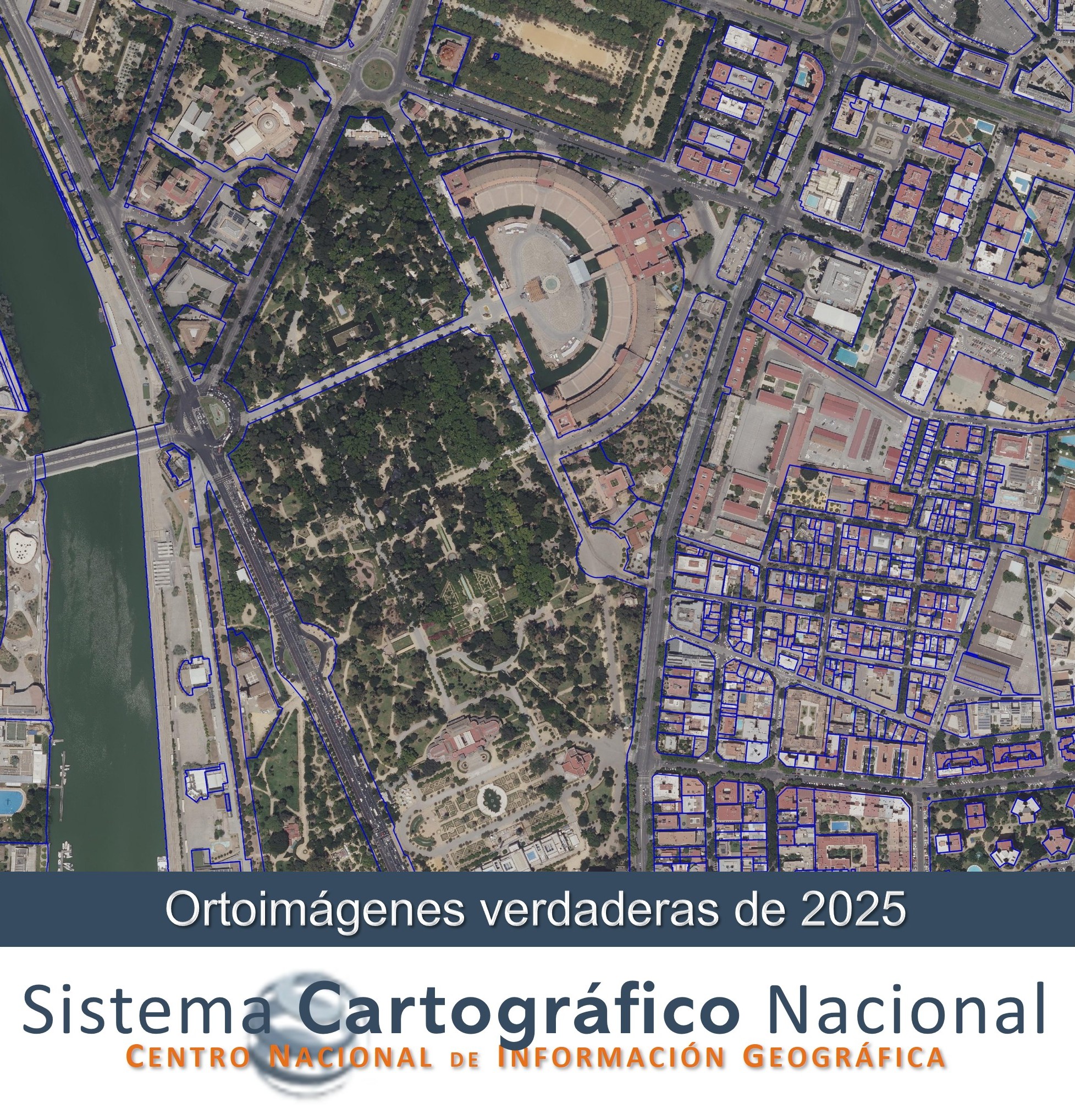
True orthophotos of 2025
True orthophotos generated from the 2025 flights of the National Aerial Orthophotography Plan for Murcia and Extremadura, with a 25 cm resolution. Obtained from the PNOA flight orientation.
The creation dates for each mosaic are:
Cáceres: November 2025
Badajoz: November 2025
Murcia: November 2025
Cartagena: November 2025
Simple
- Alternate title
-
True Orto 2025
- Date (Creation)
- 2025-11-01
- Date (Publication)
- 2026-03-01
- Citation identifier
- SCNE / TrueOrto2025
- Citation identifier
- SCNE / OrthoimageCoverage
- Presentation form
- Digital image
- Purpose
-
True orthophoto generation is a methodology that allows for the correction of all elements present in the image so that they are projected orthogonally, at a uniform scale, eliminating distortions in buildings and other elevated features, and guaranteeing a completely orthogonal representation of every point. This characteristic makes it indispensable for use cases in urban environments and areas with complex topography.
- Credit
-
Instituto Geográfico Nacional
- Credit
-
O.A. Centro Nacional de Información Geográfica
- Credit
-
Sistema Cartografico Nacional
- Point of contact
-
Organisation name Individual name Electronic mail address Role Spanish Geographic Institute
Point of contact National Centre of Geographic Information (CNIG)
Publisher
- Maintenance and update frequency
- Irregular
- Update scope
- Dataset
- Maintenance note
-
Actualización irregular
- Keywords
- Keywords
-
-
Sistema Cartográfico Nacional
-
España
-
- Specific usage
-
True orthophoto generation is a methodology that allows for the correction of all elements present in the image so that they are projected orthogonally, at a uniform scale, eliminating distortions in buildings and other elevated features, and guaranteeing a completely orthogonal representation of every point. This characteristic makes it indispensable for use cases in urban environments and areas with complex topography.
- User contact info
-
Organisation name Individual name Electronic mail address Role National Geographic Institute
User
- Access constraints
- Other restrictions
- Other constraints
- Sin limitaciones al acceso público.
- Use constraints
- Other restrictions
- Other constraints
- No se aplican condiciones de acceso y uso.
- Other constraints
- Ortoimagen verdadera PNOA 2025 CC-BY 4.0 scne.es
- Spatial representation type
- Grid
- Distance
- 0.25 0.25 metros
- Language
- Spanish; Castilian
- Character set
- UTF8
- Topic category
-
- Imagery base maps earth cover
- Description
-
Extremadura y Región de Murcia
))
- Supplemental Information
-
Próximamente
- Unique resource identifier
- ETRS89 UTM huso 29 en la Península.
- Unique resource identifier
- ETRS89 UTM huso 30 en la parte correspondiente de la Península, Ceuta y Melilla.
- Distribution format
-
Name Version Cloud Optimized GeoTIFF, COG
Unknown
Distributor
- Distributor contact
-
Organisation name Individual name Electronic mail address Role National Centre of Geographic Information (CNIG)
Distributor
- Fees
-
Free download through the CNIG's download centre
- Units of distribution
-
Each mosaic covers one MTN25 sheet.
- OnLine resource
-
Protocol Linkage Name OGC Web Map Service https://www.ign.es/wms-inspire/pnoa-ma?request=GetCapabilities&service=WMS&VERSION=1.3.0 View service (WMS) for Orthoimagery of Spain
https://centrodedescargas.cnig.es/CentroDescargas/ortoimagenes-verdaderas Download portal of CNIG
- Hierarchy level
- Dataset
Conformance result
Conformance result
- Statement
-
True RGB orthophotos generated from photogrammetric flights in urban areas with 80% longitudinal and 60% transverse overlap.
A Digital Surface Model, obtained through supercorrelation, is used with a grid spacing equal to the GSD size of the generated true orthophoto.
- Description
-
Error medio cuadrático: 3 x GSDof
Metadata
- File identifier
- spaignTrueOrto2025 XML
- Metadata language
- Spanish; Castilian
- Character set
- UTF8
- Hierarchy level
- Dataset
- Date stamp
- 2026-03-17
- Metadata standard name
-
INSPIRE Regulation Nº1205/2008
- Metadata standard version
-
TG 2.0
- Metadata author
-
Organisation name Individual name Electronic mail address Role Spanish Spatial Data Infrastructure (IDEE)
Point of contact
- Other language
-
Language Character encoding English UTF8